Global: Tropical Cyclone: Most Intense Tropical Cyclone (by Central Pressure)
| Record Value | 870 mb (25.69") |
|---|---|
| Date of Event | 12/10/1979 |
| Length of Record | 1951-present |
| Geospatial Location | Pressure Estimated in Eye of Typhoon Tip [16°44'N, 137°46'E] |
| Instrumentation | Tropical Cyclone Dropsonde |
Reference
Krause and Flood, 1997: Weather and Climate Extremes, US Army Corps of Engineers Topographic Engineering Centerpp. 89; , Dunnavan, G.M. and J.W. Diercks (1980): "An analysis of Sypertyphoon Tip (October 1979)" Mon. Wea. Rev., 180:1915-1923
Discussion
A US Air Weather Service reconnaissance aircraft recorded an onboard measurement of 700 hPa at a height of only 1900 m and a dropsonde measurement of 870 hPa
Additional Images

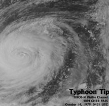
Overhead satellite view of Typhoon Tip

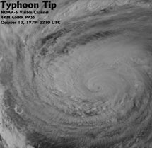
Alternate overhead satellite view of Typhoon Tip
![Closeup and Regional Satellite Images of Pacific Region for Dropsonde into Typhoon Tip Pressure Estimated in Eye of Hurricane Gilbert [16°44'N, 137°46'E]](/sites/default/files/2024-02/typhoontip1.jpg)
Closeup and Regional Satellite Images of Pacific Region for Dropsonde into Typhoon Tip
![Closeup and Regional Satellite Images of Pacific Region for Dropsonde into Typhoon Tip Pressure Estimated in Eye of Hurricane Gilbert [16°44'N, 137°46'E]](/sites/default/files/2024-02/typhoontip2.jpg)
Closeup and Regional Satellite Images of Pacific Region for Dropsonde into Typhoon Tip